Using IRIS Explorer with a Geographic Information System
by David O'Brien, NAG Limited
Geographic
Information Systems (External) (GIS) are an established technology in commerce
and science. They augment traditional databases with geographical data
so that maps can be dynamically generated and spatial models executed.
Applications include marketing, emergency services planning, environmental
monitoring and minerals exploration. Most GIS, however, are based on old
technologies which are rigidly two-dimensional and have notoriously poor
user interfaces and development tools. Users are starting to ask for more.
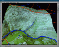 IRIS
Explorer, the popular data visualisation toolkit and application builder
from NAG, can meet these expectations. It can store and manipulate spatial
data, both raster and vector, with greater flexibility than conventional
GIS. For instance, images in IRIS Explorer may have as
many dimensions and components as required by the user. The IRIS Explorer
Map Editor
offers faster geographic model development through a closer, visual binding
of data, process and visualisation. Finally, the use of geometry based
on the Open Inventor
(External) standard used within IRIS Explorer offers more complex visualisation
techniques than conventional GIS, with the possibility of any juxtaposition
of two, three or four-dimensional methods.
IRIS
Explorer, the popular data visualisation toolkit and application builder
from NAG, can meet these expectations. It can store and manipulate spatial
data, both raster and vector, with greater flexibility than conventional
GIS. For instance, images in IRIS Explorer may have as
many dimensions and components as required by the user. The IRIS Explorer
Map Editor
offers faster geographic model development through a closer, visual binding
of data, process and visualisation. Finally, the use of geometry based
on the Open Inventor
(External) standard used within IRIS Explorer offers more complex visualisation
techniques than conventional GIS, with the possibility of any juxtaposition
of two, three or four-dimensional methods.
 For
these reasons, NAG is actively seeking to extend the range of modules that
make IRIS Explorer accessible to a wider section of the GIS user community.
This work has started with the development of reader modules that transform
popular GIS data formats into IRIS Explorer data structures. So far, we
have support for
For
these reasons, NAG is actively seeking to extend the range of modules that
make IRIS Explorer accessible to a wider section of the GIS user community.
This work has started with the development of reader modules that transform
popular GIS data formats into IRIS Explorer data structures. So far, we
have support for
- ESRI (External) (Shape)
- MapInfo
(External) (MIF)
- Ordnance Survey (NTF)
data products. These open formats are available to most GIS users, either
directly or via relatively simple conversion procedures.
The new modules transform aspatial database components into the new
IRIS Explorer data structures which have been developed by the STABLE
(External) team at NAG. STABLE is a project to build an advanced statistical system
based on IRIS Explorer's visual programming paradigm; more details are
given in the article in this issue of Render.
This connection to STABLE will make a large suite of advanced statistical
routines available to geographic analysts.
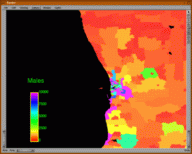
 Of
course, presentation and access are key elements of usable geographic information,
so we see it as a key and unique feature of IRIS Explorer that web-ready
visualisations may be written to VRML, the visual language of the Internet.
(For the latest news on IRIS Explorer and VRML 2.0, be sure to read the
article in this issue). In our GIS work, we have written a new module
called WriteHTML which generates HTML pages for database
records which may be aligned with links in the VRML file. Using this output,
a user on the Internet or an intranet can just click on, for example, a
census district to view its records for population, home ownership and
so on.
Of
course, presentation and access are key elements of usable geographic information,
so we see it as a key and unique feature of IRIS Explorer that web-ready
visualisations may be written to VRML, the visual language of the Internet.
(For the latest news on IRIS Explorer and VRML 2.0, be sure to read the
article in this issue). In our GIS work, we have written a new module
called WriteHTML which generates HTML pages for database
records which may be aligned with links in the VRML file. Using this output,
a user on the Internet or an intranet can just click on, for example, a
census district to view its records for population, home ownership and
so on.
Keep an eye on the IRIS Explorer website for background, demonstrations
and downloadable components of the new GIS support for IRIS Explorer. In
the meantime please contact the Helpdesk
for more information.
Last modified: Mar 16 14:47 1999
[ Contents :
Render Home :
Next Article
]
© NAG Ltd, Oxford UK. 1999